GEOGRAPHY
The greater part of Armenia is situated on the southern flanks of the Caucasian mountain range. The country covers approximately 29,800 square kilometers. The neighboring countries include Turkey to the West, Georgia to the North, Azerbaijan to the East, and Iran to the South. Its significant geographical features include Lake Sevan and Mount Aragats (4,090m).
POPULATION
The last census was held in the Fall, 2001. According to the results publicized in Spring, 2003, Armenia ’s population is around 3.2 million people. According to the census of 1989, Armenia ’s population was 3.4 million people with ethnic Armenians comprising 89%, Azeris 4%, Russians and others 7%. Since that census, the ethnic makeup has changed significantly, with ethnic Armenians now comprising perhaps 95-96%. This came as a result of (a) a mass exodus of Azeris from Armenia; (b) the return of Russian, Ukrainian, Jewish and Greek families to their home countries (caused by the deterioration of living conditions in Armenia), and (c) the difficulties of development in this blockaded country. More...Furthermore, starting in 1992, there was a new trend as members of the Armenian labor force began to move abroad to CIS countries, Europe , and the United States —trying to find employment and support their families left behind in Armenia . To various estimates, some 500,000 to 700,000 people have left. It is impossible to predict what percentage of these people will return.
Approximately seventy percent of Armenia 's population lives in urban areas. Yerevan alone includes more than one-third of this total. Unlike many former Soviet Republics , Armenia has (and has always had) substantial ethnic and religious homogeneity.
HISTORY
According to some interpretations of the Bible, paradise may be found in Armenia , where Noah landed his ark on Mount Ararat . On the Babylonian world map, Armenia is shown next to the Assyrian and Babylonian civilizations. Ancient Greek maps show Armenia on the northeastern boundary of the thenknown world. Over its more than 4,000 year-long history, the Armenian plateau, which lay between three seas, served as the crossroads of ancient intercontinental trade routes. It faced numerous political victories and downfalls, long periods of scientific, cultural, and artistic prosperity, with incredibly devastating periods of hunger, deprivation, and Genocide.
Armenia has played the role of a world superpower during certain periods of its history. From the ninth to the sixth centuries BC, the Urartu (Ararat) Kingdom rivaled the powerful Assyrian Kingdom . In the First Century BC King Tigran the Great led Armenia against the Roman Empire . At different stages of their history, Armenians created strong national state systems throughout historical Armenia . The Bagratoonee Dynasty of the ninth to the eleventh centuries AD and the Cilician Kingdom of the twelfth to the fourteenth century are two examples of such states.
In 301, Armenia became the first nation to adopt Christianity as its official, state religion. The year of 2001 was special for the 1700 th anniversary celebration events. Subsequently, when in 405 Mesrob Mashtots developed the 36-letter Armenian alphabet, the first manuscript translated was the Bible. The development of the Armenian alphabet allowed the proliferation of literature and the strengthening of the National Armenian Apostolic Church . Armenian is an independent member of the Indo-European language group.
Armenia has often fallen under foreign rule. From the fifth to the seventh centuries, the Persian and Byzantine Empires ruled Armenian territories. From the seventh to the ninth centuries, Arab forces entered the region. The period from the thirteenth to the nineteenth centuries saw the Ottoman and Persian empires dividing historic Armenia . Regardless of the governing powers, the Armenian people always continued to occupy their historic homelands. Moreover, one of its districts—Mountainous Kharabakh (Artsakh) succeeded in retaining real political power until the nineteenth century.
Despite its long history, the systematic study of Armenia ’s language, culture, and ancient civilizations began only 100-150 years ago. In this short period of time, however, evidence has emerged that seems to indicate the development of sophisticated social and economic activities throughout Armenian territories. These include the fields of astronomy, agriculture (wheat, barley, grapes, pomegranates, and apricots), metallurgy, carpet weaving, horse breeding, construction, and architecture. The works of Medieval Armenian historians, philosophers, physicians, poets, and artists have contributed to world culture.
There are many interesting sights in Armenia today—even though it occupies less than 10% of the territory of historic Armenia . Visitors can tour the ruins of ancient metallurgical sites dating to the beginning of the third millennium BC in the Metzamor region. The world’s only natural reserve of ancient wheat can be found at Yereboonee. No tour of Yerevan is complete without a visit to the magnificent Matenadaran Museum , where manuscripts and written material collected over the past 1,500 years are preserved and studied. More than 10,000 architectural sites grace Armenian landscapes: Zvartnotss, Hripsimeh, Yererook, Noravank, Garrnee, Geghard, and Hakhpat, to name just a few.
The darkest days of Armenian history occurred from the 1880s to the 1930s. The Ottoman Empire , the transitional government of the Young Turks, and Kemal Ataturk’s state undertook the systematic extermination of the entire Armenian population located throughout Western Armenia . This Genocide reached its peak during the Young Turk regime—especially between 1915 and 1918—under cover of the First World War, when Turkey was Germany ’s ally.
An estimated 1.5 million Armenians were either slaughtered in Anatolia , or were forced on tragic death-marches into the Syrian Desert . Since then, Armenians throughout the world commemorate April 24 th as the day on which, in 1915, the Genocide began with the murder of the Armenian intelligentsia in Constantinople ( Istanbul ). After the collapse of the Russian Empire in 1918, Armenia briefly regained its independence until 1920, when it was incorporated as one of the fifteen republics of the Soviet Union .
On September 21, 1991 , as a result of a national referendum, the citizens of Armenia almost unanimously voted for independence. Armenia became a formal member of the United Nations in March 1992 and of the Council of Europe in 2001, and has already established diplomatic representations in many capitals abroad.
In 301 AD, St. Gregory the Illuminator (Saint Grigor Luisavorich) converted to Christianity King Tiridates III (Trdat) of Armenia who had incarcerated him earlier for refusing to offer sacrifice to the pagan goddess, Anahit. Grigor was released from imprisonment because of a miraculous cure through the works of God that he provided to the King. Later, the king converted to Christianity and officially declared Armenia a Christian nation. Armenia became the first nation in the world to formally accept Christianity as its religion. In the year 2001, Armenians celebrated the 1700 th anniversary of the official conversion and dedicated a new cathedral in downtown Yerevan.
SIGHTSEEING
Usually every few weeks, you are invited via email messages to participate in outings organized by the Faculty Services office. The following are descriptions of some of the trips.
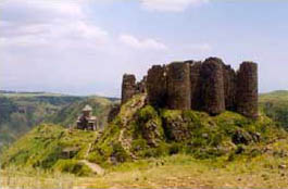 Amberd Fortress, 9th century, 6 km from the village of Byurakan, is in the district of Ashtarak, on the slopes of mount Aragatz. The fortress stands on a rocky cape formed by the rivers Amberd and Arkhashen. There are also vestiges of a fortified three-storied palace, a church built in 1026, a palace bathhouse with two domes, a central heating system, water tanks, a water-supply system, and a secret passage to a nearby cleft, and other buildings. Amberd Fortress, 9th century, 6 km from the village of Byurakan, is in the district of Ashtarak, on the slopes of mount Aragatz. The fortress stands on a rocky cape formed by the rivers Amberd and Arkhashen. There are also vestiges of a fortified three-storied palace, a church built in 1026, a palace bathhouse with two domes, a central heating system, water tanks, a water-supply system, and a secret passage to a nearby cleft, and other buildings.
Byurakan Observatory was founded in 1946. It is in the Ashtarak district and is located on the southern slope of Mt. Aragats at an altitude of about 1,500 m. It was one of the largest observatories of the Soviet Union. Since its foundation, it has been named after academician Victor Hambartsumyan. The observatory has a one-meter diameter Schmidt Telescope, one of the larger ones in the world, as well as a 53-centimetre Schmidt Telescope, and 50 and 40-centimetre mirror telescopes. In 1976, a 2.65-meter diameter mirror telescope was constructed there. The Byurakan Observatory is a branch of the National Academy of Sciences.
Makaravank is a medieval architectural church complex in the Ijevan district, on the slope of Paitatap Mountain. The main church was constructed in 1205 of pink andesite. The oldest church of the complex was constructed in the 10th-11th centuries of large pieces of rough-hewn red volcanic tuff (a common Armenian building material). The construction material for the "gaveet" (separate 13th century building reserved for meetings) is of red andesite. On the Eastern side of the church complex of Makaravank you can see St Astvatsatsin (Mother of God) church in white stone. The religious leader, Hovhanness, built it in 1198.
Church of St. Hripsimeh was built in Etshmiadsin on the orders of Catholicos Komitas in 618. The date of the church is confirmed by Catholicos Komitas' two signatures (one inside the building, over the Eastern apse; the other, outside, over the Western entrance to the cathedral), and also by Sebeos, a 7th century historian. The architectural forms, decorative motives of the window ledges and numerous marks of master masons show St Hripsimeh's affinities with its 6th-7th century counterparts. It is interesting to consider the church's stone structures, particularly; the sub-dome transition with the enormous, well elaborated stepped squinches.
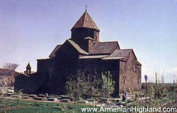 Church of St. Gayaneh was built in Etshmiadsin by Catholicos Yezr in 630. Contemporary authors (Sebeos) and the church's construction and decorations (squinch and sub-dome transition, the window ledge and architrave carvings, entrances, mason's marks, etc.) confirm the dating. Slender and delicate proportions are a distinguishing feature of the cathedral, as is the uplifting sweep in design that remains unchanged despite partial 17th century renovations of the dome and of some ceilings. An airy, arched portico - the burial place for top Armenian clergy that adorned the Western facade was also added. Church of St. Gayaneh was built in Etshmiadsin by Catholicos Yezr in 630. Contemporary authors (Sebeos) and the church's construction and decorations (squinch and sub-dome transition, the window ledge and architrave carvings, entrances, mason's marks, etc.) confirm the dating. Slender and delicate proportions are a distinguishing feature of the cathedral, as is the uplifting sweep in design that remains unchanged despite partial 17th century renovations of the dome and of some ceilings. An airy, arched portico - the burial place for top Armenian clergy that adorned the Western facade was also added.
Tegher. It is a church complex of the 13th Century AD in the village of Tegher in the Ashtarak district. The complex consists of a domed church and a gaveet. The wife of Prince Vatsheh Vatshoutian, Mamakhatoon, ordered Vartapet Aighbaireek to build this church. Construction lasted from 1213 to 1232.
The architectural ensemble in Taleen (7th century) Two 7th century structures lie at the entrance of Taleen, a district center. One is a small cruciform church built by Prince Nerses Kamsarakan in the second quarter of the 7th century. This tetraconic church has a rectangular western wing. A double-banded squinch transition and an octahedral drum characterize the structure of this comparatively modest building. By contrast, the cathedral is a variation of domed basilicas-with apses projecting from the north, the east and the south. Thick pylons support a dodecahedral drum. The transition to the dome foundation is through the use of pendentives. The cathedral's construction dates back to the second half of the 7th century. It is lavishly decorated. The original 7th century decoration has survived, in part, on the window ledges and elsewhere. There are many 5th-7th century steles with remarkably interesting reliefs that trace their origin, iconographically, to the earliest works of Christian art.
Church of St. John in Mastara, late 6th century, in the Taleen district. A sub-dome square, with apses extending on its four sides, culminates in an imposing dome that governs the whole of the church's interior. Four large squinches in combination with overhanging arches provide a solid foundation for the huge octahedral drum of the dome. Its architectural conception heralds another stage in the development of simple cruciform compositions, a transition to complex church designs like those in Avan and St Hripsimeh in Etshmiadsin. The works of medieval architecture in Mastara include, among others, numerous khatchkars (cross-stones).
 The Churches of Ashtarak. Ashtarak is a town 20 kilometers northeast of Yerevan. It straddles the Kassakh River. Ashtarak is identified in historical documents from the 9th century as a rural town. There are many architectural monuments in Ashtarak including the churches of Karmravor and Tseeranavor (7th century) and Speetakavor (13th-14th century), and the cloister of Marineh (13th century), The Churches of Ashtarak. Ashtarak is a town 20 kilometers northeast of Yerevan. It straddles the Kassakh River. Ashtarak is identified in historical documents from the 9th century as a rural town. There are many architectural monuments in Ashtarak including the churches of Karmravor and Tseeranavor (7th century) and Speetakavor (13th-14th century), and the cloister of Marineh (13th century),
Lake Sevan or Geghama Sea or Gegharkooneek Sea is the largest (1,416 m2) lake in the Caucasus and the highest (1,916 m) fresh-water lake in the world. The average length of Sevan is 19 kilometers, the average width is 18 kilometers, but in some places the maximum width is 56 kilometers. The average temperature in the Sevan area is about +170 C with a maximum of +320 C. The average temperature below zero is -70 C and the minimum drops to -320 C. The level of the lake has gradually decreased due to the consumption of water in Armenia. Now, the level is some 31m lower than the original, natural level. After the construction of the Arpa-Sevan tunnel, the level of the lake rose annually by approximately 12 cm. When the Vorotan-Arpa tunnel will be ready, the level will rise by a further 12 cm. There are 28 rivers flowing into Sevan. The larger ones are the Djknaget, Gavaraget, Arjeetjee, Vardenees, Karchaghbyoor, and Masreek. Only one river - the Hrazdan (or Zangoo) - flows out from Sevan. The Urartian name of this river is Ildaroonee. The length of the river is 14 kilometers. Hrazdan's waters flow into the Arax River that delineates most of the Armenian border with Turkey. There are various kinds of fish in Sevan. The most famous is the ishkhan trout, but there are also the koghak, begloo and seega (white fish).
The Sevan Peninsula. There was an island in Lake Sevan but now it has become a peninsula because of the lowering water level of the lake. There are two churches on the peninsula - the Arakelots (Apostles) and the Astvatsatsin (Mother of God). King Ashot Bagratooni's daughter, Mariam, constructed both churches in 874. The churches were reconstructed in 1956-57.
The town of Sevan. Before 1935, the town was named Yelenovka. The Russian religious group of molakans (an offshoot of the dookabors or Anabaptists exiled by the Russian Tzar in 1842) founded it. Until the end of the 19th century, Russians populated Yelenovka, the present population is 93.6% Armenian. There are many resorts in the town. There is a fishery and a fiberglass plant.
Haghardzeen is a monastic complex 18 km East of Delijan. It dates from the 10th to the 13th centuries and is in the historical Dzorapor district. The complex has three churches with a number of khatchkars, dormitory, and chapels. One of the older churches of the complex is the Saint Gevorg church (10th century). The church of the Holy Mother, which is the main church of the complex, dates from 1281. The dormitory was built in 1248. Saint Stepanos church was built of blue basalt in 1244. There are several chapels on the site and a 350 kg bronze cauldron made in 1232.
The Memorial to Yugoslav Pilots. In 1988 a Yugoslav aircraft crashed near Etshmiadzin. It was bringing humanitarian aid for the 1988 Spitak Earthquake victims. Six Yugoslav pilots perished. The government of Armenia built a memorial on the crash site.
Sardarapat is a fortress in the old Armenian Khan (Armaveer district). It was founded by the brother of the Yerevan Sardar (ruler) - Hassan Khan, on the ruins of an ancient fortress. Sardarapat was at the crossroads for caravans coming from Karin and Gharss. A customs service was created adjacent to the fortress. Russian troops captured this fortress on September 20, 1827.
The Sardarapat Battle Memorial was constructed in 1968. It commemorates the battle of Armenian troops against the attacking Turks in 1918. The Turks, using the situation in the Caucasus region, decided to capture not only Western, but also Eastern Armenia, and all of Transcaucasia. In 1918, starting on February 10, and in two months, the Turks captured Karin (Erzroom), Sareeghameesh, Gharss, and Alexandropol. They tried to reach Yerevan through Sardarapat. Yakoob Shevkee Pasha was the commander of the Turks, while Colonels Seeleekyan and Peeroomyan headed the Armenian troops. On May 22-26, the Turks suffered a crushing defeat and retreated leaving 3,500 dead. This victory saved Armenia from being conquered by Turkey - and prevented the predictable usual historical sequel of a mass Genocide.
 Saghmossavank is located in Ashtarak district near Saghmossavank village, by the Kassakh River. It is a medieval architectural complex, comprising of St Zion church, a printing house, the Church of the Mother of God, and cross-stones. Prince Vatsheh Vatshootyan constructed St. Zion church (1215). Prince Kyood Vatshootyan constructed the publishing house and the Church of the Mother of God. A 13th-14th century cemetery with many cross-stones is located north of the complex. Saghmossavank is located in Ashtarak district near Saghmossavank village, by the Kassakh River. It is a medieval architectural complex, comprising of St Zion church, a printing house, the Church of the Mother of God, and cross-stones. Prince Vatsheh Vatshootyan constructed St. Zion church (1215). Prince Kyood Vatshootyan constructed the publishing house and the Church of the Mother of God. A 13th-14th century cemetery with many cross-stones is located north of the complex.
The architectural complex of Sanaheen is located near Alaverde, on a high plateau. Its earliest building is a cross-domed Church of the Virgin (930s). Its focus, however, is the Cathedral of the Savior (967-977). The church of St Gregory, circular in the interior but with a cruciform exterior, was built in 1061. The book depository (1063) - the Academy of Gregory the Master - is a vaulted building between the Church and the Cathedral. It dates from the 11th century. There also is a 12th-13th century sepulcher of the rulers. A four-column gaveet on the western side of the Church of the Savior dates back to 1181. A three-nave, vaulted gaveet on the western section of the Cathedral dates from 1211. The site also has a 13th century belfry. On the eastern side, under the gable, there are bas-reliefs of the benefactors, King Smbat and King Goorghen Bagratoonee. Part of the interior wall painting has also survived.
The architectural complex of Ohanavank is in the village of Ohanavank, in the Ashtarak district. Its buildings rise along the edge of the picturesque canyon of the Kassakh River. The earliest part of the ensemble started in the 5th century. The building of the cruciform, domed church dates from 1216. It is made of large tuff blocks that stand some two meters tall. A large columned gaveet on the western side of the main church has an open rotunda over its central section. The defensive wall around the complex's periphery dates back to the 13th-14th centuries. The site also includes many bas-reliefs and khatchkars.
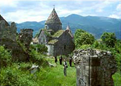
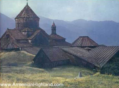 The Architectural complex of Haghbat is in the Tamanyan district. The complex's earliest development is the domed Cathedral of the Holy Cross (977-991). The eastern side has sculptures of the patrons, King Smbat and King Goorgen Bagratoonee, both holding a model of the church in their outstretched hands. Small domed churches in the ensemble include the church of St. Gregory (1005) and that of the Virgin dating from the 13th century. A gaveet on the eastern side of the Holy Cross Cathedral is an exemplary version for this type of building. It was constructed in the early 13th century when it came to replace a more ancient structure. The roof rests on four crisscrossed arches. The second gaveet - Hamazasp's Gaveet (1257) - is a four-columned structure with a yerdeek (skylight). At some distance from the ensemble is a three-storied belfry (1245): a vivid example of contemporary ensemble constructions. The roofing of the 13th century book depository also rests on crisscrossed arches. A large 13th century refectory, outside the monastery building, is similarly covered. Eastward, there is a three-arched fountain-reservoir, dating from 1258. Within the monastery grounds, there are a number of splendid 11th-13th century khatchkars, among them the "Amenaprkeetch" (Savior) khatchkar with an elaborately carved crucifix. It stands inside the roofed gallery encompassing the main cathedral from the north and the east (13th century). The dwelling houses in Haghbat are regarded as splendid specimens of 19th century Armenian folk construction. The Architectural complex of Haghbat is in the Tamanyan district. The complex's earliest development is the domed Cathedral of the Holy Cross (977-991). The eastern side has sculptures of the patrons, King Smbat and King Goorgen Bagratoonee, both holding a model of the church in their outstretched hands. Small domed churches in the ensemble include the church of St. Gregory (1005) and that of the Virgin dating from the 13th century. A gaveet on the eastern side of the Holy Cross Cathedral is an exemplary version for this type of building. It was constructed in the early 13th century when it came to replace a more ancient structure. The roof rests on four crisscrossed arches. The second gaveet - Hamazasp's Gaveet (1257) - is a four-columned structure with a yerdeek (skylight). At some distance from the ensemble is a three-storied belfry (1245): a vivid example of contemporary ensemble constructions. The roofing of the 13th century book depository also rests on crisscrossed arches. A large 13th century refectory, outside the monastery building, is similarly covered. Eastward, there is a three-arched fountain-reservoir, dating from 1258. Within the monastery grounds, there are a number of splendid 11th-13th century khatchkars, among them the "Amenaprkeetch" (Savior) khatchkar with an elaborately carved crucifix. It stands inside the roofed gallery encompassing the main cathedral from the north and the east (13th century). The dwelling houses in Haghbat are regarded as splendid specimens of 19th century Armenian folk construction.
Oshakan is a village in Ashtarak district located on the banks of the Kassakh River. Pavstos Byoozand mentioned it in the first half of the 4th century. Mesrob Mashtotss was buried in Oshakan in 442. A circular church, with domes, was built on his grave. There is some evidence that Mesrob Mashtotss founded a school in Oshakan. In 1876-79, Catholicos Gevorg constructed a new church on the site of the old one constructed in 443 by Vahan Amatoonee. In 1960, H. Meenassyan decorated the church walls. Adjacent to the church, there is a chapel constructed in 1884. To the north of Oshakan is St Zion church. The cemetery of Emperor Moreek is located in Oshakan. Catholicos Nahapet constructed the bridge on the Kassakh in 1706. A memorial to the Russian-Persian war victims (1827) was constructed here in 1833. A memorial dedicated to the 1600th anniversary of Mesrob Mashtotss' birth was constructed in 1962: two slabs of basalt in the form of an open book on which is engraved the Armenian alphabet.
Gladzor is a village in the Vayotss Dzor district, 3 km to the north of the district center, Yeghegnadzor. The present inhabitants emigrated from the Iranian village of Soma in 1830. Gladzor University (1291) was a famous medieval Armenian educational and scientific institution associated with Aghberd's church with, at its head, Nerssess Mghetsee. The university closed in 1340. Until 1331, its rector was Yessayee Mshetsee, and its most famous academic was Teeratoor. Gladzor University had its internal charter, an academic degree system, and oral examinations. It was similar to a University of Political Science or Art in its content and specialization. There were three auditoria for:
- educational, internal, and external texts,
- the arts: sculpture, manuscript production, miniature paintings, and music,
- theology, mythology, grammar, rhetoric, logic, arithmetic, astronomy, and geometry.
Special attention was given to Philosophy. Gladzor University trained 350 graduates as teacher-priests for Armenian cultural centers. Studies lasted for 7-8 years. Graduates received a sound knowledge that gave them an opportunity to teach. Degrees were awarded during a festive ceremony and each candidate for a degree had to make an oral presentation.
Noravank is a remarkable architectural complex of the 13th-14th centuries, about 3 km to the east of Amagoo near Yeghegnadzor (Vayotss Dzor region). In the beginning of the 13th century, Noravank was the spiritual center of Syunik district and the Orbelee princes' residence. The architect Siranes and the remarkable miniature painter and sculptor Momeek worked here in the latter part of the eighth century. The St Karapet church has a dome on its western side, and Prince Smbat's mausoleum on the north. The two-storied mausoleum-church is located to the southwest of the main group. St Karapet church was built by Prince Leepareet Orbelyan (1216-1223). In 1340, an earthquake destroyed the dome. In 1361, the dome was reconstructed by the initiative of the architect Seeraness. Later, in 1931, during another earthquake, the dome was damaged. The fortress walls surrounding the complex were built in the 17th-18th centuries. In 1948 and 1949, the roof and the walls of the two-storied church were repaired.
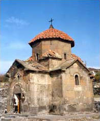
Khor Veerap (deep pit) is a 17th century monastery-fortress in the Ararat district. This site became a famous pilgrimage site through its connection with Gregor (Loosavoritch), the Enlightener. In ancient times, the historic city of Artashat was situated here, and a fortress was built nearby. The prison (the "deep pit") was full of snakes and poisonous insects. Convicts were tossed inside. According to Agathangeloss, however, Gregor survived here for thirteen years until his release by the King. In 542, Catholicos Nerssess the First constructed a church on this miraculous site. The church was similar to that of Zvartnotss. The current church was constructed on the ruins of the first church. The Veerap is a pit with a diameter of about 4.5 m and a depth of 6 m. Khor Veerap monastery was a well-known academic center. In the 13th century it had about forty pupils.
Mount Aragats (also known as Alagyaz or Alagyoz) is located between the Ararat and Shirak valleys and between the Akhooryan and Kassakh Rivers. Aragats is the fourth highest mountain in the Armenian highlands. It has four peaks. The highest is the northern peak (about 4,090 meters), the western (4,080 meters), the eastern (3,916 meters) and the southern (3,879 meters). There is a volcanic canyon with a depth of 350 meters and a length of 3,000 meters on the top of Aragats. Many wild animals live in the Aragats area. There are field mice, hares, foxes, wolves, snakes, lizards, and different kinds of birds. The rivers, Gegharot, Amberd, Nareeshd, Mantash, Geghadzor, and Tsakhkahoveet, originate here. Lakes Karee, Amberd and Leseeng are also located on this mountain.
Lake Karee is at an altitude of about 3,190 meters. The depth of the lake is about 8 meters. The lake's cold and clear waters cover an area of 1,900 m2.
Lake Leseeng (3,200 m) is about 2.5 m deep and covers just 160 m2. The temperature of the water in summer is less than 90 C.
Lake Amberd (3,220 m) is 150 m long and 248 m wide.
The town of Goris was founded in 1870 as a center of the Zangezoor district of the Russian province of Yelizavetpol. Goris is about 245 km southeast of Yerevan. It lies in the valley of the Goris River - a tributary of the Vorotan River. The escarpments, hoodoos, and caves that abound here offer a unique landscape. The climate is relatively mild. In January, the average temperature is about 30C and, in July, climbs to 190C. When the Goris-Shoushi-Yevlakh road was built in 1882, Goris became an important economic and commercial center. It was the fourth largest town after Yerevan, Alexandropol (Gyumri), and Nor Bayazed (Gavar). The town boasts many unique buildings designed by German architects, a museum and a monument to the great Armenian writer, Axel Bakoonts.
The architectural complex of Tatev (near Goris on a long and tortuous narrow road) dates from the 9th century. It is one of Armenia's most celebrated medieval architectural sites and is built on an ancient sanctuary. The St. Poghoss and St. Petross cathedral is, perhaps, the earliest among the group of buildings here (895-906). Its structure-particularly its freestanding columns-is similar to other works of the 7th century. This cathedral, however, has a western extension: later to become a popular trend in Armenian architecture. The buildings were badly damaged in the 1931 earthquake and renovation is in progress. South of the main church is the vaulted church of St. Gregory (1295), which replaces an earlier 9th century church. The ensemble also comprises an 11th century domed gate-church and a memorial column. This remarkable structure rocks on its base and has survived from the early 10th century. It is octahedral, almost 9 m high, made of small stones, and topped by a cross. The periphery of the crag is built up with a variety of homes, utility buildings, and other structures: including a vaulted font and fortifications from the 17th century.
Jermuk is about 173 km from Yerevan and is located on the upper slopes of the Arpa River. The climate here is mountainous with cool summers and long, snowy winters. In January, the average temperature is about -90C and in summer, 180C. Jermuk is a spa. The water here is similar to that of Djeleznavodsk (Russia) and Karlovi Vari (Czech Republic). Jermuk's springs are recommended for gastro-intestinal problems as well as for liver and kidney deficiencies. The water is commercially bottled and sold throughout the country.
The Jermuk Waterfall is located in Jermuk. It originates from many springs. The height of the waterfall is about 60 m and falls to the Arpa River in three stages (basins).
The Shakeyi Waterfall is in the Vorotan canyon and lies 3 km from Seessyan, on the river Shakeyi. The waterfall is about 18 m high. The waters are used for the nearby Shakeyi hydroelectric power station.
The architectural complex of Garrnee was Armenia's foremost center of Hellenistic culture and the summer residence of Armenian kings. It was a fortress in the 3rd century BC and a heathen temple in the 1st century AD. It is now a village in the Kotayk district, some 35 km southeast of Yerevan. A pagan temple was unearthed in 1909-1911 by Academicians Marr and Smirnov. Since 1949, an archaeological group under Professor Arakelyan (Institute of Archaeology and Ethnography of the Armenian Academy of Sciences) has been at work here. As a result, the ruins of a Neolithic camp, a Urartian cuneiform text of the 8th century BC carved on a dragon, and inscriptions in Greek, Aramean and Armenian provide evidence of many centuries of uninterrupted human existence. A Greek inscription carved on a huge basalt block mentions the reconstruction of a fortress by King Trdat. Garnee also has a 5th century single-nave church outside the fortress walls and a 7th century domed church, cruciform on the inside but with a multiplane exterior, directly adjacent to the pagan temple. A 9th century building here is the vaulted sepulchre of the Catholicos Mashtotz. A number of buildings inside the present-day village of Garrnee and its environs date back to the 11th-13th centuries. Archeologist Saheenyan has restored the pagan temple.
The architectural complex of Geghard (Ayreevank). Geghard is one of Armenia's most significant medieval architectural ensembles and lies some 5 km southeast of Garnee. According to legend, it was founded in the 4th century. The most ancient cave-church of St. Gregory (7th century) is outside the monastery walls. The principal structure, the church of the Virgin, is a cruciform building from the second quarter of the 13th century. It has a four-column gaveet (1225) to the west of the church. Two cave-churches were constructed in 1263, along with the family sepulchre of the Proshyan Princes. Their coat of arms is carved in the rock: two chained lions and an eagle with half-spread wings, whose claws grasp a calf. The architect Galdzagh built both structures. Carved in the rock, somewhat above the sepulchre, is the four-column burial place of Prince Papak and his wife Hroozakan (1288). It clearly recalls other 12th-13th century four-column gaveets. A number of artificial caves and many khatchkars are also visible.
Arznee is a small resort about 22 km north of Yerevan along the Hrazdan River. Arznee became a resort town in 1922 but the mineral springs of Arznee were known long before. Winters here are mild and summers, cool. There are three resorts for adults and one for children. The springs of Arznee are about 80 m deep. The waters are taken for gastro-intestinal diseases as well as for the liver, heart, and gynecological problems. There is a domed, small church of the 7th century with unusual, round windows.
Bjnee is a village in the Hrazdan district. There is a bottling factory for "Bjnee" mineral water. The springs were discovered in 1967. The waters are recommended for diseases of the gastro-intestinal tract. The historian Ghazar Parpetsee first mentions the village in the 5th century. In the 11th century, Bjnee was identified as a fortress. In 1072, the Seljuk-Turks conquered Bjnee. Armenian and Georgian troops liberated Bjnee in 1201 and it became the fiefdom of the Zakaryans till the 14th century. In 1386, the Mongols, led by Tamerlane, sacked Bjnee.
The architectural ensemble of Bjnee (6th-13th centuries) A small cruciform 7th century chapel stands atop a rocky crag. The domed church of the Virgin (1301) and, in the distance, a 10th-11th century fortress with remnants of secret passages, a church and other structures are also to be seen. The many 11th-13th century khatchkars are famous masterpieces of this art form.
|
